Monday, May 27, 2013

References and Introductions

Hello,

The following blog was comprised as part of a Geography 201 Spring course focussing particularly on Physical Geography. Photos not taken by myself are credited and the book Physical Geography: The Global Environment by H.J. de Blij was used as a source of reference and detail. For more in regards to referencing and sources, please feel free to contact me. I hope you enjoy the blog!

Sources:  de Blij, Harm J, et al. Physical Geography: The Global Environment . Oxford University Press, 2009.


Chapter 3: Mapping the Earth's Surface

Geocaching, GPS & Global Mapping


Geocaching is a game of sorts wherein an item is placed at a specific destination and then the coordinates are given to a different party for the purpose of them eventually discovering that location. GPS’s come in handy here as the coordinates are fed into the device and specific points of the mystery item are given out and made able to track. As a device, the GPS is now widely available, expanded from its original use strictly by government personnel, the military and scientists. Now most cars come with the device built-in, and remarkably, the system connected to more than twenty four satellites orbiting the Earth is compacted and at ready disposal of the majority. This picture was taken during a field trip taken to geocach as a class, and although a bit hard to see, I am holding the green capsule from the day.    

Chapter 4: Earth's Setting in Space

To Infinity...and Beyond!


Like the Greeks before us, human beings remain astounded by moving celestial bodies, planets, and many space expeditions are conducted still with the hope of discovering more about these revolving bodies part of our solar system. The image with me in is of our Milky Way galaxy, believed to have been formed more than twelve billion years ago. Simply said, man is fascinated by space, or rather, the idea that more exists beyond the literal horizon. With all the effort thrown into space exploration and planet study, it is little wonder that the perceived solution to Earth’s depleting resources lies somewhere in space.   


Chapter 5: Composition and Structure of the Atmosphere

Put the Kettle On


The kettle boiling is releasing steam into the atmosphere, and this translucent water vapour in turn then evaporates. Although invisible, this gaseous form of water both stores and absorbs energy and is transported by air currents, taking with it stored energy. This process, the movement of water vapour, is essential in moderating surface temperature, thus making it appropriate for humanity's habitation.

Chapter 7: Atmospheric and Surface Temperature

Say NO to Smog.


Smog is the backdrop to most industrialized economies. Factories produce large amounts of heat and release this energy, along with harmful chemicals burned by the plants, into the atmosphere. In most cases this is done on a daily basis, and in cities like Edmonton, a cloud of grey industrial smoke covers the tops of buildings and industrial plants. The release of smog is a form of pollution in the atmosphere causing higher levels of ground-level ozone and consequent depletion of the ozone layer. As we continue to search for more renewable resources, the smog enveloping most of our bustling cities serve as deadly reminder to the hazards the Earth faces if more by way of conservation efforts is not done.    


Chapter 8: Air Pressure and Winds

Blame it on the Coriolis


The Earth rotates, and this movement affects direction of atmospheric circulation, the most essential effect being expressed as an outward deflecting force. Coriolis, the deflective force, in the absence of other forces deflects moving objects by hemisphere, the right being north and left in the south. Winds travelling from the North Pole then become easterlies as they are deflected right, and as a whole, Coriolis plays an important role in deciding general patterns of atmospheric circulation. 


Chapter 9: Circulation Patterns of the Atmosphere

Nature Puts Up a Good Front


As the atmosphere works to redistribute heat and moisture throughout the Earth’s surface, air travels from areas of high to low concentration. Climates are controlled by intricate reactions between these atmospheric circulation as well as movement and properties of oceanic waters. The surface circulation model seen in this picture is obviously idealized; hence the actual design is decidedly more multifaceted.  


Photo credit: http://www.learner.org/courses/envsci/unit/text.php?unit=2&secNum=6

Chapter 10: Hydrosphere: Circulation of the World Ocean

Out to Sea


Currents, like the ones seen flowing in the photo can be generated via a number of ways. The first way is through water accumulating by the coastline, resulting in a slightly elevated sea level than the ocean surrounding. Next, variation in the density of seawater plays a role in affecting deeper zones beneath the surface layer, and the foremost source of ocean currents is the frictional drag on the surface of the water. With the water subject to its force, Coriolis then manoeuvres surface currents to flow at angles of 45 degrees right or left depending on the hemisphere (North and South).  

Chapter 11: Atmospheric Moisture and the Water Balance

Something in the Clouds


Clouds are a part of any beautiful day, and the sun shining would not be the same without a nice covering of layered stratus clouds in the sky. Moreover, a picnic would be incomplete without fat, puffy cumulus clouds to stare at, cumulus being the "shapes" in the sky both children and adults indulge themselves in deciphering shapes from. Cloud classification is common in meteorology as a practice and without clouds; precipitation could not fall to the Earth. The thicker and more condensed the clouds, the more likely it is to rain. Fortunately enough, the clouds from this picture do not spell thunderstorms any time soon!  

Chapter 12: Precipitation, Air Masses, and Fronts

Is it Still Raining?


Warm fronts are generally associated with light or moderate rainfall and involve the sequencing of status clouds. Days of persistent, but gentle precipitation and humid temperature are the doing of warm fronts. Rain continues to fall throughout the day as layered stratus clouds fill the sky, and areas affected go beyond the actual surface passage of the front. The tendency of warm fronts to extend themselves is the reason rainy weather in Edmonton might spell showers, or gloomy weather for areas like Sherwood Park and Red Deer. 

Photo credit: http://www.flickr.com/photos/natural_and_happy/31708371/

Chapter 13: Weather Systems

Temperature and Weather Systems


A surplus of heat marks the equatorial and tropical latitudes, bringing forth the energy to carry along winds, evaporating and carrying substantial amounts of seawater in the process. Due to a surplus of water vapour, gathering of trade winds and recurrent convection, heavy rains seen in the tropics are produced. Not restricted to low-latitude weather systems, the thermometer seen in the picture represents the general concept of weather tracking and humanity’s preoccupation with weather systems.


Chapter 14: Severe Weather

Brr...It's Cold in Here.


All good Albertans know that the province is absolutely freezing between the months of January and March, and most Canadians expect the extreme weather such as blizzards and icy snow storms as part of the climate. Brief seasonal periods of heat are enjoyed during the summer months, but mainly the land is covered by snow. When blizzards occur, higher wind speeds transporting huge amounts of snow tend to take even the most experienced Edmontonian by surprise. In these extreme weather conditions, snow is transported very rapidly by winds, and as the temperature steeps, one can only bundle up tightly. Avoiding the rapidly falling snow, and possibly hail, it is not uncommon for vehicles to pull to the side of the road, or for people to seek shelter and wait as the storm slowly passes.

While blizzards can be better in damages when compared to other severe weather such as hurricanes, they are cold and unpleasant all the same. The two top pictures of a recent blizzard were taken in February from the Edmonton region.  


Chapter 15: Weather Tracking and Forecasting

And Today's Forecast is...


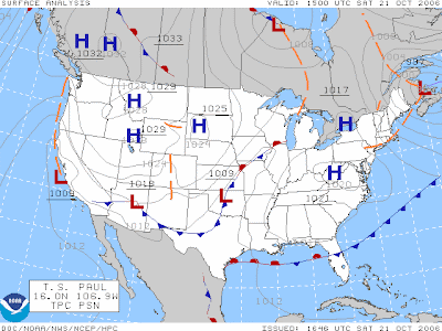
It is the tendency of present culture to look to the news or weather report for daily information on the climate at any given time, whether it is for warnings predicting extreme weather events, or simply the daily forecast. The weather map is made up of a number of essential details, symbols representing the temperature shown in degrees, dew point temperature and air pressure being a few. We look to weather maps like the illustration above because they provide an idea of what the weather will be as a result of alternating winds and their patterns. In this way, we almost attempt to predict nature, but as is the common case with weather forecasts, they can never be 100% accurate.  


Chapter 16: Climate Classification and Regionalization

Different Strokes for...Different Weather Folks?


Weather patterns differ considerably across the Earth’s surface and modern scientists attempt to manage these numerous climates by generalizing by way of commonality. These classifications are divided into regions and from there, six major climate groups. Depending on a number of controlling factors, altitude, topography and latitude being just a few, the concept of “climate” is established. From this idea it is then possible to have certain expectations depending on region and season. Florida is sunny, Britain is damp and primarily overcast, and Canada is home to fur-wearing Eskimos…all these concepts are born from the idea of climate and alternating regions.


Chapter 17: Global Climates

Determining the Weather


Albertan weather is unique, and although it is unpredictable, inhabitants still have an idea of what to expect depending on the month and season. The same can be said of warmer climates like Australia where snowfall is extremely scarce, but locals know to bundle up more during winter months and the extent to which they need to warm themselves. With this said, what works there cannot be expected to sustain in harsher Canadian weather. The months are still the same, however, the severity of the seasons is entirely dependent on climate.

While it might mean nothing to wear shorts and a t-shirt during the months of January and February in Australia, doing the same in a city like Edmonton would mean hypothermia and certain frostbite. Hence, the two global climates are alike in that mid-latitude cyclone generated storms do usher in a consistent flow of moist maritime air from the ocean to close land surfaces, but difference in temperature and climate is due to the extent of inland penetration and is dependent on topography. 

Chapter 18: Dynamics of Past and Present Climate Change

Climate Change (Past and Present)


The norm of our planet is climate change, and although global warming and the melting of Polar Ice Caps signify negative change, our planet is constantly altering. For example, the fossilized tree from The Royal Tyrell museum, seen in the picture above, proves that the world does not stand still and that minute-by-minute imperceptible changes to our landscape and structures are ongoing. Just as glaciers expand and break off, trees and soil are subject to erosion. Data obtained from fossils like the weathered tree are then combined and inspected to determine what the environment might have been billions of years ago. In fact, it is through data of this kind that knowledge of the Earth during the time of dinosaurs is obtained.    


Chapter 20: The Layered Interior

The Earth and its Layers in an Avocado


The Earth is comprised of multiple layers and the avocado featured in the picture is intended to illustrate the concept of its layered interior. The pit of the fruit correlates with the solid inner core, the next layer as the liquid outer core, the upper mantle being the green flesh and the Earth's crust represented as the green rough outer layer and covering of the avocado.  

Chapter 21: Impact Cratering

Now You See Me...


A comet, such as that responsible for ending the age of the dinosaurs, would rank ten on the Torino Impact Hazard Scale, the high rating translating to mean certain global climactic catastrophe born from the collision, destruction capable of threatening the very future of civilisation. At a glance, it is inconceivable that fossils like that of the Woolly Mammoth seen in my picture are the few remains of the Mesozoic era left today, impossible that a comet was capable of wiping out giants like the dinosaurs.

Yet, the comet alone is not responsible for the dinosaur’s extinction; rather, it is the chain of events set into play from the moment it penetrated the Earth’s crust that is to blame. Unimaginable chemical changes to the atmosphere, cataclysmic volcanic reactions, unprecedented high winds and severe storms are only a fraction of the overall changes the climate underwent overall. Therefore, keeping this in mind, it becomes easier to understand how beasts like the dinosaurs could perish from one collision to the Earth.  It is arguably for this very reason that the Torino scale was established,  so that humanity is made capable of tracking comets and asteroids the like in order to anticipate damages born from those hazardous impacts in order to meet the danger as best possible. 

Chapter 22: Minerals and Igneous Rocks

All Minerals are NOT Created Equal!


As a metal, gold is commonly prized for its long association with stature and wealth. Although these few pieces of shredded gold are not as prized as the Queen’s gold bars might be, gold as a precious metal is still one of the world’s most prized minerals. Because all minerals have unique properties that differentiate them from others, gold cannot be mistaken for diamond or even quartzite. Not only do the colours, hardness, lustre, streak and cleavage differ, but their very chemical compositions set them apart. In this way, two different minerals are most certainly not created equal. 


Still referred to, to this day, the Mohs Hardness scale lists diamonds as being the hardest mineral. These rings can cut! 

Chapter 23: Sedimentary and Metamorphic Rocks

Hoodoos


The Hoodoos, large sedimentary rocks, are comprised of a combination of sandstone and mudstone, resulted due to the processes of lithification. Displays of colour and texture make sedimentary rocks hard to miss and make evident the environments to which they were deposited. In a way, sedimentary rocks are necessary in reconstructing concepts of past environments, ecosystems, the rocks harbouring as well precious fossils. An example of the very same, The Hoodoos seen in the picture are folded and layered with evidence of cross-bedding like most sedimentary rocks.   

Chapter 24: Lithospheric Plates and Plate Movement

The Glaciers are Coming!


Continents drift, and as these landmasses pull apart, or together, volcanoes and earthquakes can come about as a result. Landmasses thicken due to movement of the plates, and like Jasper’s Athabasca Glaciers, form towering structures. If we were to hypothetically remove ten percent of the upper mountain, the landmass would lift as a result of isostasy. 


Photo credit: http://www.tripadvisor.ca/Attraction_Review-g154917-d155171-Reviews-Athabasca_Glacier-Jasper_National_Park_Alberta.html

Chapter 27: Surface Expressions of Subsurface Structures

Stress Folds


Rocks of all properties are responsible for the shaping of landforms, even the Maligne Canyon of Jasper, Alberta. As is seen in the photograph, the structure’s surface has undergone a number of stresses, so much so that is has folded in on itself and fractured in other parts. Due to tensional forces continuously stressing the area, slippage has occurred along the fault, pulling until the middle section of the Canyon has been left vacant and gaping as a result. 


Photo credit: http://www.cityknown.com/Cities/Attraction.aspx?BusinessID=1533

Chapter 28: Formation of Landscapes and Landforms

The Dunes


The aggregation of similar landforms creates the landscape of the Jasper Sand Dunes. The region has been modified to an extent by weathering and erosion, the forces of nature having helped to shape the landscape. A sand dune is essentially an accumulation of sand particles or sediment carried in by coastal waves, then transported by the forces of wind, over time building to form structures like the one seen above. In the formation of the dunes in particular, wind contributed to the standing sand dunes and to this day continues to modify the landscape. 


Photo credit: http://www.panoramio.com/photo/64276904

Chapter 31: Water in the Lithosphere

Miette Hot (Healing) Springs


 A spring is flowing water sprouting from the ground, most commonly induced by an acquiclude barring the downward separation of water, making it flow instead from a hillside. Hot springs, like the Miette hot springs in Jasper originate from springs lying directly above the crust of the Earth containing magma chambers close to the surface.  Also called mineral springs, hot springs contain a good amount of minerals broken down from surrounding rocks, and because of this the water is alternately used for medicinal purposes. This explains the popularity of said attractions!


Chapter 32: Slopes and Streams

Childhood Kickback


This childhood picture, taken by the river barely captures the true depth of the body of water featured or its many fluvial processes. The river is a part of the hydrologic cycle, meaning that should water fall on raised landmasses, it will inevitably flow back in the direction of sea level due to gravity’s pull. As this water flows downstream, it produces kinetic energy and this force carries sediment produced by weathering processes at increased velocities, and both “flows” water and sediment help in deciphering the river system’s behaviour. In this case, the river shown in the photograph is low in kinetic energy due to its lethargic flow downstream, hence one might say that this particular flow suggest the disparity of sediment in the river shown.   

Chapter 33: Stream Erosion

The Edmonton River Valley (Larchlands)


Much can be revealed by analysing drainage patterns of a stream, specifically about the underlying geology. As an erosional force, the efficiency of the drainage system is immediately related to the drainage density, and consequently the strength of the drainage density is then directly related to the system’s erosional efficiency. Should the stream seen behind me in this photograph be analysed, its patterns would make it possible to discover the stream’s hidden geology.   

Chapter 34: Aggradational Landforms of Streams

The Edmonton River Valley


Like much of the world’s major streams, those of the Edmonton Larchlands are a part of a drainage system that will inevitably flow into the oceans as opposed to a closed basin. A loss in stream capacity during its latter course, without the presence of proper slope, brings an end to the degradation process and starts aggrading, setting up alluvial landforms.  The meanders seen in the picture are bends in the stream channel where erosion occurs, deposition happening on the inside of the meanders while erosion takes place on the outer sides.

Chapter 35: Karst Processes and Landforms

Old-Time Tracking


The mountain my siblings and I are climbing is comprised somewhat of dolostone formed by complex karst processes. Multiple factors of erosion contribute to the overall stratigraphy of the mountain and although it cannot be seen from the picture, water connects directly to the structure flowing in streams underneath.   

Chapter 36: Glacial Degradation and Aggradation

Harder than it Looks


Glaciers, like the one seen above are subject to the thermal regime of ice, associated in kind to the glacial mass balance. Outlet glaciers like the Athabasca are classified as “active ice” and are fed by a steady fund of ice from a neve. The glaciers experience erosion, this taking place by abrasion. However, other forces such as temperature of the basal ice, the glacier’s movement and character of the underlying rock play a part in glacier erosion since ice by itself is not a hard material. The process occurs gradually and degradation happens through glacier movement; as streams carry sediment, sharper rocks cut into the base of the glacier. 


Photo credit: http://jasperjournal.com/jaspergallery/v/glaciers/DSC03676_glacier_Jasper.jpg.html

Chapter 37: Landforms and Landscapes of Continental Ice Sheets and Mountain Glaciers

No Life Without Ice


Landforms such as the Athabasca Glacier are products of snow having covered the area and later been frozen to ice. The term recessional moraine may be applied to the Glacier as it recedes, the ice melting to flow into the river below. Although our present heated climate, due to global warming, is certainly not ideal for the endurance of glaciers such as the Athabasca, these mountain glaciers continue to survive although mass from the structures is lost at an ever growing rate. Should things continue at this rate, greenhouse gasses heating ever more the planet, we could very well be looking at the iceless remains of the glacier in future.  


Photo credit: http://www.hihostels.ca/westerncanada/1527/HI-Athabasca-Falls/Activities--Programs/index.hostel

Chapter 41: Coastal Processes

Preserve the Land! (for more embarrassing pictures in future).


The space whereupon lands meets sea is known as the littoral zone. As can be seen from the photograph, many activities occur along the coast, whether it is embarrassing picture-taking, sailing or sight-seeing. The existence of this strip of land, or shoreline, allows for people to delve into the waters in whatever way they choose while allowing the possibility of a return to shore.  In interacting with the ocean, we impinge on the land, often at times this contact being more negative than good. Everything washes onto shore eventually, the shore itself baring testament to this as a product of the forces of aggradation. Sadly, it is a waste as well as humanity’s loss that harmful waste and garbage continue to be the result of our contact with nature.   


Chapter 42: Coastal Landforms and Landscapes

The beach and the Waves


Sand largely makes up the beach seen in this picture, unlike other beaches born from the accumulation of dark igneous rocks. The forces of aggradation have undoubtedly helped shape the structure of the shore seen in the dated photo.  Sediment carried to the beach from streams helped form the rocks seen just behind my siblings and me. This is not to say that particles from the physical breakdown of greater rocks and sea cliffs are not responsible for the formation of the minor and darker dunes. In fact, these sediments may have been carried, degraded, by the wind only to wash onto shore in aggradation.  

Chapter 43: Climate, Soil, Plants, and Animals

Hey, Earth bottle!


The above picture is of me holding a water bottle halfway filled with soil taken from the garden. The study of soil, pedology helps comprise the field of biogeography which among the geography of animals also studies the geography of plants. Often taken for granted, the earth, “ground” or soil is the very basis for plant life on earth. The soil offers the plants and trees vital nutrients, and in turn the plant life release decaying organic matter that is then converted back into reusable nutrients. Just looking at the brown dirt one might not expect that soil can actually die, or that its role in our ecosystem is as vital as it is, but without the soil there would be no trees and therefore no oxygen. We need the soil as much as the trees siphoning nutrients or birds pulling worms from beneath the earth, and we are undoubtedly all interconnected.